Yuewen Dai
Analyze and Design for our cities
Master of Urban Spatial Analytics @ UPenn
B.Arch @ Huahzong University of Science and Technology
I'm exploring the field of data analysis, design and visualization. View My LinkedIn Profile
As an urban analyst and designer, I’ve explored a range of fields from city scale to community and architecture scale. Check my projects below👇
Predictive Machine Learning Modelings and Analysis
Chesapeake Bay Landcover Change Precision Prediction
This project aims to develop a precision forecast model for land cover change at the Chesapeake Watershed. By leveraging high-resolution longitudinal land cover data provided by the Chesapeake Conservancy, the model will predict land cover conversions from pervious to impervious surfaces. This forecast will enable land use and environmental planners to identify where urban growth will occur, propose green infrastructure accordingly, and prioritize lands for protection. The model will be generalizable to the county level, incorporating only widely available inputs, thus allowing any municipality within the Chesapeake basin to replicate the analysis. This proof-of-concept project will demonstrate the utility of precision conservation in land protection and green infrastructure planning and provide a valuable tool for planners and policymakers across the region.
Skiils Used: R, Machine Learning, ArcGIS
California Wildfire Risk Prediction and Application
The wildfire has always been a severe problem in California. Both the property damages and the physical and psychological damages done to people are enormous, and it also have long-term impacts on air quality, water resources, and ecosystems. To better control and reduce the risk of wildfires, the government has taken many preventive measures. However, given any preventive measure requires significant government funding, and the resources are limited, the government wants to be able to invent every dollar precisely to where it is needed to control spending. Therefore a more accurate means of predicting where wildfires will occur is needed.
Skiils Used: R, Machine Learning(Bionomial Regression), ArcGIS
Housing Price Prediction in Mecklenburg County
Zillow is an US real-estate marketplace company, it provides its users with house features information as well as estimations for homes that have undergone major changes. However, Zillow has realized that their housing market forecasts are not as accurate as they could be due to a lack of regional intelligence. In this project, we collected housing feature data, geographic data and census data, an then developed a machine learning model for Zillow to better predict the housing price in Mecklenburg County.
Skills Used: R, OLS Modeling, Spatial Lag
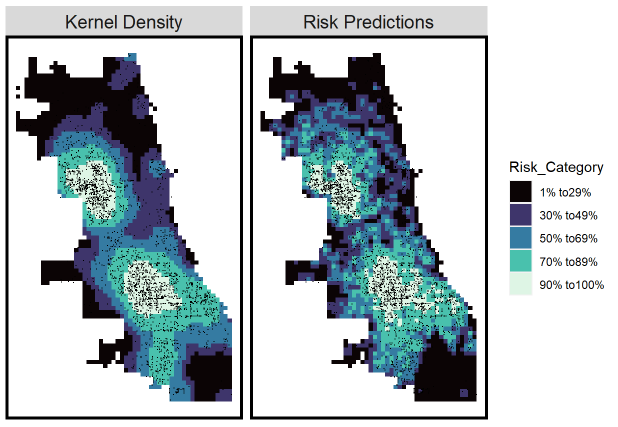
Crime Risk Prediction in Chicago
Crime has always been a key factor in cities that has a great impact on land values, zoning, resource allocation, etc. Analyzing crime-related factors and making predictions on crimes can help policymakers decide on regional policies, help police deploy resources more rationally, and also help people visualize the safety of a region more directly. Here, I developed a risk prediction model by borrowing experiences from places where crimes has been observed.
Skills Used: R, Poisson Regression
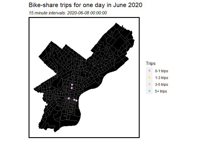
Bikeshare Prediction in Philadelphia
Indego, Philadelphia’s bike-share program, offers options to ride shared electric bicycles available at over 140 stations around the city, accessible all year round. It provides people a more convenient way to travel short distances. However, it would be a problem if people go to a station but find that there are no available bicycles or if people are ready to return bikes but find no space available, so it’s important to carry out a re-balancing plan for the bikeshare company. In the project, I build a model to predict the peak space/time usage of bike-share so that the re-balancing program can be carried out effectively.
Skills Used: R, Modeling time(Serial Correlation)
Web Visualization
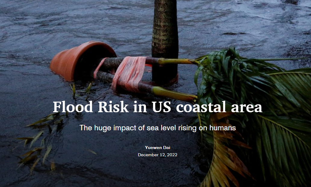
US Coastal Flood Risk
Floods have brought great losses to US coastal areas and will cause even more damage in the future due to sea level rise. The severity of the flooding cannot be visualized by looking at the numbers alone. Here, I use data, map and other media sources to show you the severity of floods and how people deal with this problem.
Skills Used: ArcGIS (& Online Platform)
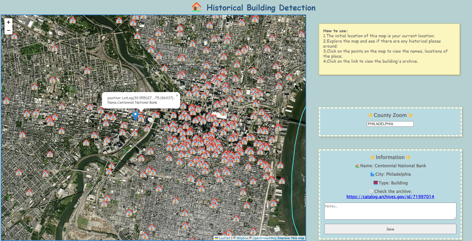
Historic Constructions Detection
This is a useful interactive map tool for exploring architectures in the city. For tourists and architects, this app will help them find the historic sites on map, read the introductions of the buildings, and add their own notes.
Skills Used: JavaScript,css, html, Leaflet, Firebase, R
Spatial Analysis
Predict Median House Values in Philadelphia Block Groups
Our goal in this research is to investigate any spatial autocorrelation in neighborhood variables and investigate ways to potentially enhance the findings. Using Philadelphia data at the Census block group level, we will use GeoDa and ArcGIS to run spatial lag, spatial error and geographically weighted regression to see whether these methods can explain the spatial autocorrelation that might remain in the OLS residuals.
Skills Used: ArcGIS, GeoDa, R, Spatial lag& Spatial error& GWR
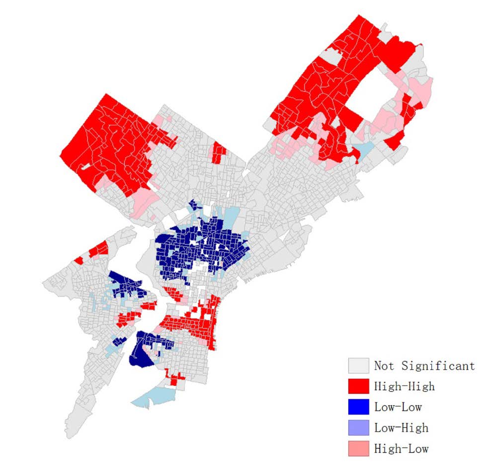
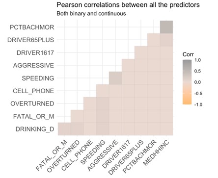
Examine the Predictors of Car Crashes Caused by Alcohol
Our goal in this research is to identify predictors of accidents related to drunk driving. To predict the drunk driving, we should run the Logistic regression in R to see the extent to which drunk driving might be associated with the predictors.
Skills Used: R, Logistic Regression
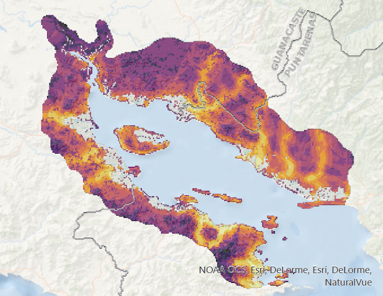
Where to build a shrimp farm in Costa Rica
In recent years, Costa Rica has been developing organic and sustainable shrimp farming. In particular, it is trying to move the production away from mangrove forests, as intensive shrimp farming is destructive to that environment. It also encourages a practice that moves away from the heavy use of chemicals and antibiotics. This project is built for farmers to find where to locate a organic and sustainable shrimp farm.
Skills Used: ArcGIS
The likelihood of future gun violence in Philadelphia
This project calculates the probability of future gun violence happens in Philadelphia using existing point data.
Skills Used: ArcGIS
Architecture and Urban Design
Hanyang Iron Plant Reconstruction Design
Hanyang Steel Works is China’s heavy industry production base in the last century. However, for decades, its operation has also caused great damage to the surrounding environment. The natural ecology has been irreversibly damaged. This design aims to implant biological systems into the ruins of abandoned industrial plants through human intervention, so that nature can regain the right to speak. While achieving ecological sustainability, by organizing spaces where nature and architecture intersect each other, it promotes the re-harmonization of man and nature.
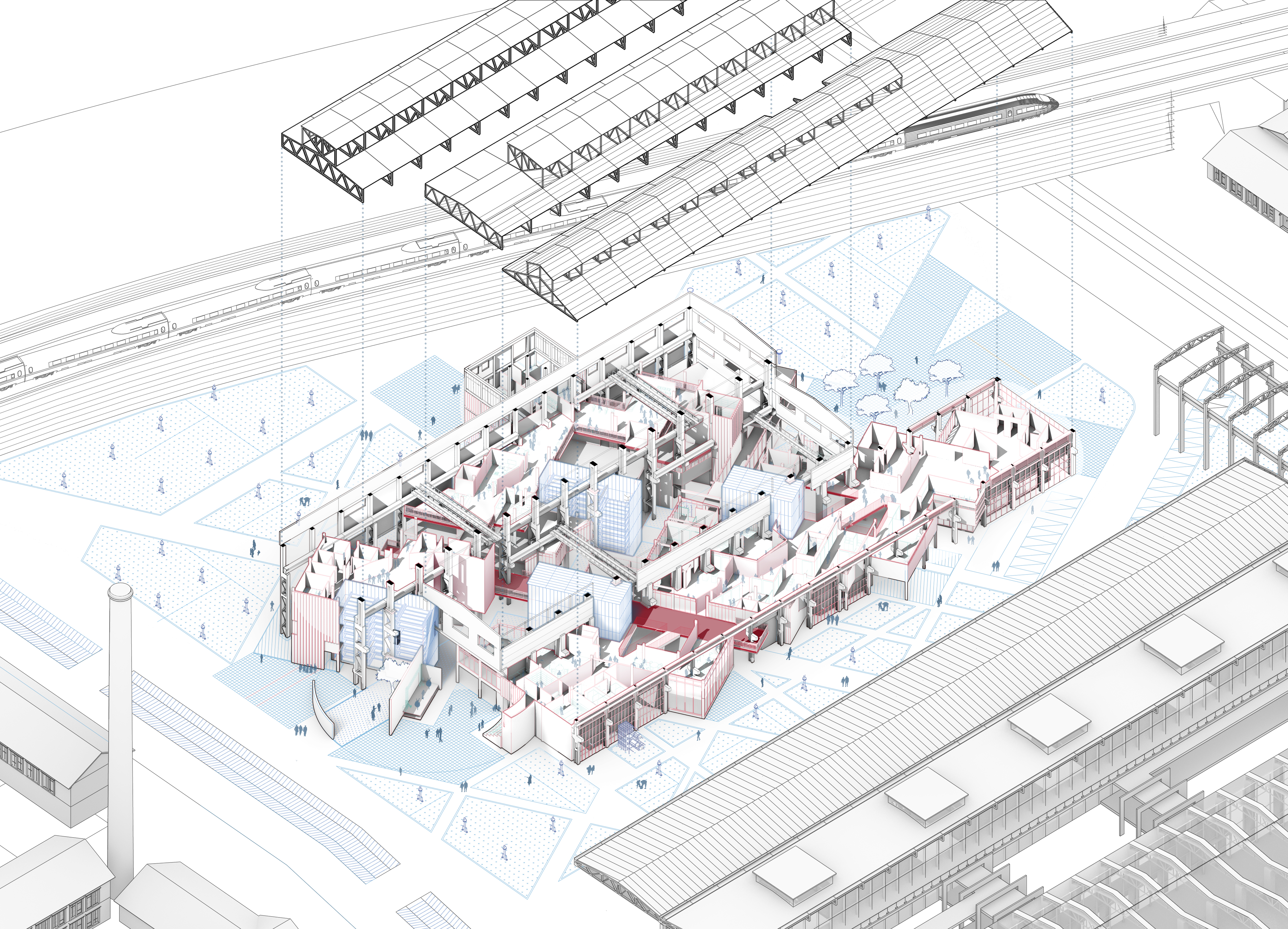
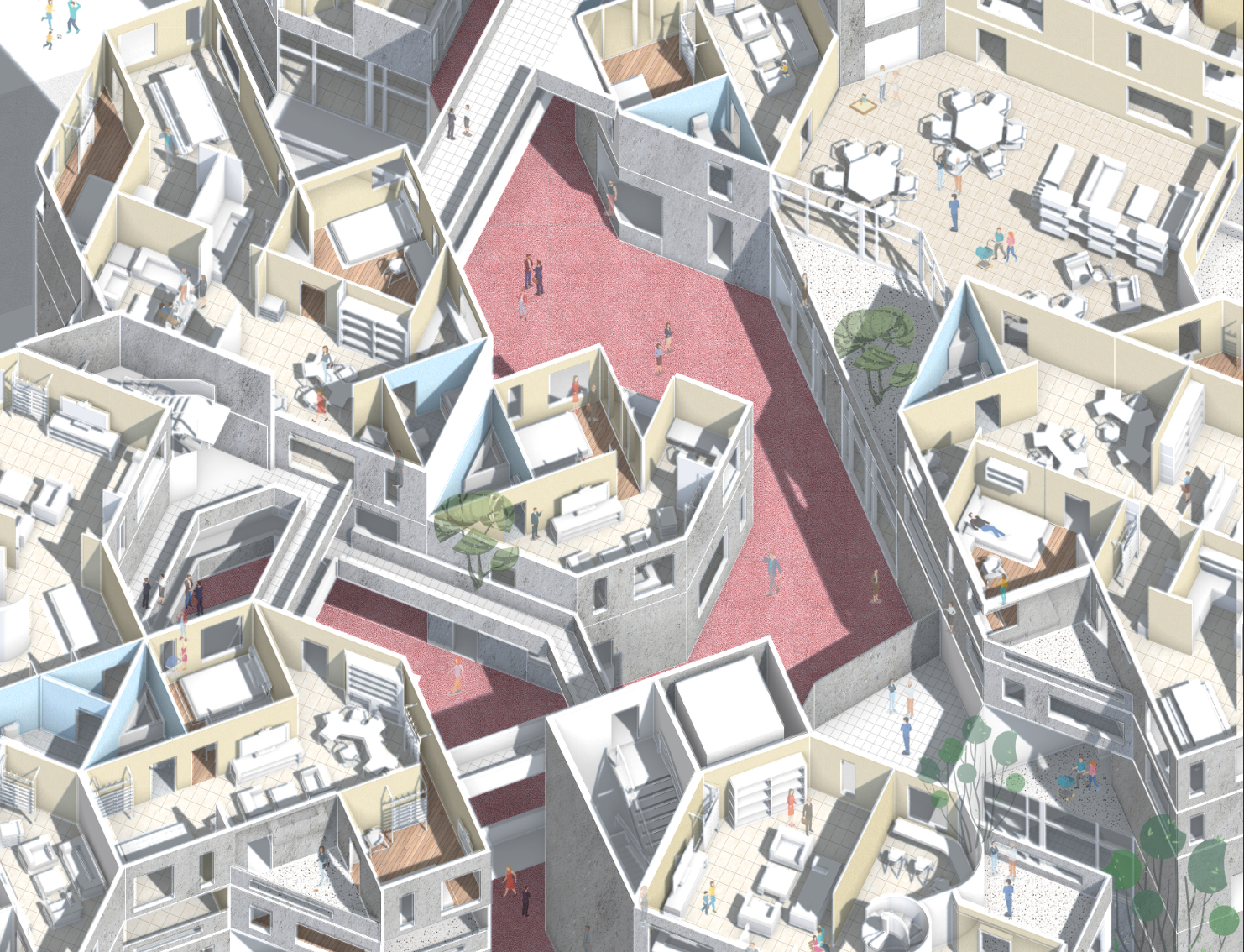
Young Migrant Collective Housing
This project is located in the Ziyang area of Wuhan, Hubei. On the north side of the project plot, there is one of the most important urban roads in Wuhan-Wuluo Road, which connects many important universities in Wuhan and serves as a bridge connecting Wuhan to the north and south rivers. Public transportation is developed on Wuluo Road. Considering that many colleges and universities on both sides of Wuluo Road can introduce a large number of young people to the land, the main population of residential design is young people.
Wuhan Changhong School Campus Design
Taking the new site of Changhong Middle School in Wuhan as an example, this project attempts to introduce a new communication space system on top of satisfying
basic teaching, so that the traditional teaching space and the independent exploration space are intertwined and collided. There are the following innovations in the teaching mode: 1. Insert two sets of intersecting space systems, 2. Add open shared space, and 3. Integrate traditional teaching space and new teaching space. The design concept is not only presented in the planning and layout, but also in the interior graphic design and façade design. Ultimately, an open campus space with both order and freedom will be established to provide support for future innovative teaching.